________________
178
THE INDIAN ANTIQUARY
(June, 1876.
ves.
of trade, or, failing these, has recourse to my ruins and deserted, the walls and bastions rethological legends or fabulous narratives. main. The interior of this is filled with trees
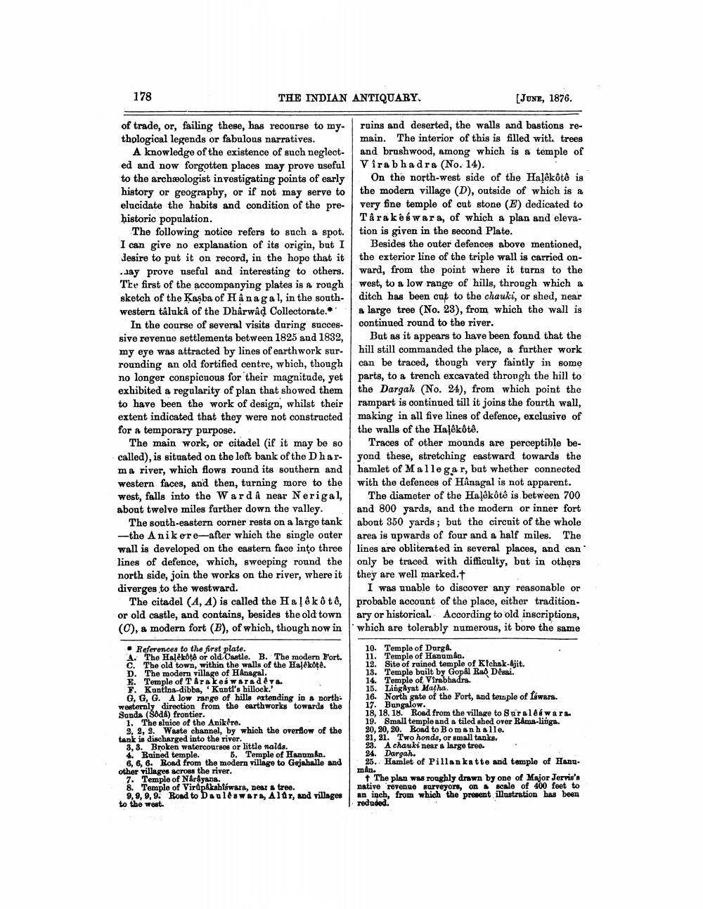
A knowledge of the existence of such neglect- and brushwood, among which is a temple of ed and now forgotten places may prove useful Virabhadra (No. 14). to the archæologist investigating points of early 1 On the north-west side of the Haļskôtô is history or geography, or if not may serve to the modern village (D), outside of which is a elucidate the habits and condition of the pre- very fine temple of cut stone (E) dedicated to historic population.
Târa késwara, of which a plan and elevaThe following notice refers to such a spot. tion is given in the second Plate. I can give no explanation of its origin, but I Besides the outer defences above mentioned, desire to put it on record, in the hope that it the exterior line of the triple wall is carried on..Jay prove useful and interesting to others. ward, from the point where it turns to the The first of the accompanying plates is a rough west, to a low range of hills, through which & sketch of the Kaşba of Hânagal, in the south- ditch has been cut to the chauki, or shed, near western täluka of the Dharwad Collectorate. " a large tree (No. 23), from which the wall is In the course of several visits during succes.
continued round to the river. sive revenue settlements between 1825 and 1832, But as it appears to have been found that the my eye was attracted by lines of earthwork sur. hill still commanded the place, a further work rounding an old fortified centre, which, though can be traced, though very faintly in some no longer conspicuous for their magnitude, yet parts, to a trench excavated through the hill to exhibited a regularity of plan that showed them the Dargah (No. 24), from which point the to have been the work of design, whilst their rampart is continued till it joins the fourth wall, extent indicated that they were not constructed making in all five lines of defence, exclusive of for a temporary purpose.
the walls of the Halékôté. The main work, or citadel (if it may be so Traces of other mounds are perceptible becalled), is situated on the left bank of the Dhar- yond these, stretching eastward towards the ma river, which flows round its southern and hamlet of Mallegar, but whether connected western faces, and then, turning more to the with the defonces of Hanagal is not apparent. west, falls into the Ward â near Nerigal, The diameter of the Haļêkôtô is between 700 about twelve miles farther down the valley. and 800 yards, and the modern or inner fort
The south-eastern corner rests on a large tank about 350 yards; but the circuit of the whole -the Anikere-after which the single outer area is upwards of four and a half miles. The wall is developed on the eastern face into three lines are obliterated in several places, and can lines of defence, which, sweeping round the only be traced with difficulty, but in others north side, join the works on the river, where it they are well marked.t diverges to the westward.
I was unable to discover any reasonable or The citadel (A, A) is called the Haļêkôte, probable account of the place, either tradition. or old castle, and contains, besides the old town ary or historical. According to old inscriptions, (C), & modern fort (B), of which, though now in which are tolerably numerous, it bore the same
• References to the first plate. A. The Halékota or old Castle. B. The modern Fort. C. The old town, within the walls of the Haļékote. D. The modern village of H&nagal. E. Temple of Tarakeswarades. F. Kantina-dibba, Kuntt's hillock.
G, G, G. A low range of hills extending in & northwesternly direction from the earthworks towards the Sands (S0d) frontier.
1. The sluice of the Anikere.
3, 2, 3. Waste channel, by which the overflow of the tank is discharged into the river.
3,3. Broken watercourses or little nalds. 4. Ruined temple. 5. Temple of Hanuman.
6, 6, 6. Road from the modern village to Gejahalle and other villages across the river.
7. Temple of Nerdyana. 8. Temple of Virdpakahfáwara, Dear a tree.
9,9, 9, 9. Road to Dauleswara, Aldr, and villages to the west.
4បទាំង-ថ្មី
10. Temple of Durg. 11. Temple of Hanoman. 12. Site of rained temple of Kichak-Sjit. 13. Temple built by Gopal Rao Desai. 14. Temple of Virabhadra. 15. LingAyat Matha. 16. North gate of the Fort, and temple of fowars. 17. Bungalow. 18, 18. 18. Road from the village to Suraleswaru. 19. Small temple and a tiled shed over Ramos-liiga. 20, 20, 20. Road to Bomanhalle. 21, 21. Two honds, or small tanks. 23. A chauki near a large tree. 24. Dargah. 25.. Hamlet of Pillankatte and temple of Hanu.
The plan was roughly drawn by one of Major Jervie's native revenue surveyors, on scale of 100 feet to
which the present illustration 1. redaded