________________
Chapter 01
Introduction to Research
miles through Tibet and Kashmir, between the Ladakh and Zanskar mountain ranges. Turning southwest, the river seeks a southern passage to the Arabian Sea through Pakistan.
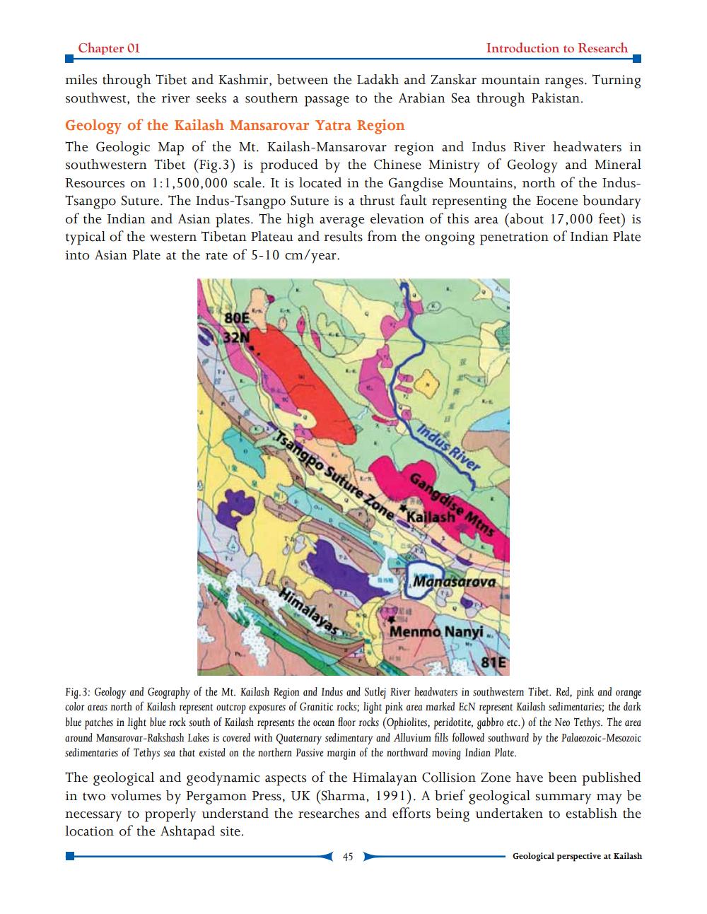
Geology of the Kailash Mansarovar Yatra Region The Geologic Map of the Mt. Kailash-Mansarovar region and Indus River headwaters in southwestern Tibet (Fig.3) is produced by the Chinese Ministry of Geology and Mineral Resources on 1:1,500,000 scale. It is located in the Gangdise Mountains, north of the IndusTsangpo Suture. The Indus-Tsangpo Suture is a thrust fault representing the Eocene boundary of the Indian and Asian plates. The high average elevation of this area (about 17,000 feet) is typical of the western Tibetan Plateau and results from the ongoing penetration of Indian Plate into Asian Plate at the rate of 5-10 cm/year.
180E
Indus River
Isangpo Suture Zone
Gangdise Mtns
Manasarova
Himalayas
AT Menmo Nanyi.
81E
Fig.3: Geology and Geography of the Mt. Kailash Region and Indus and Sutlej River headwaters in southwestern Tibet. Red, pink and orange color areas north of Kailash represent outcrop exposures of Granitic rocks; light pink area marked EcN represent Kailash sedimentaries; the dark blue patches in light blue rock south of Kailash represents the ocean floor rocks (Ophiolites, peridotite, gabbro etc.) of the Neo Tethys. The area around Mansarovar-Rakshash Lakes is covered with Quaternary sedimentary and Alluvium fills followed southward by the Palaeozoic-Mesozoic sedimentaries of Tethys sea that existed on the northern Passive margin of the northward moving Indian Plate. The geological and geodynamic aspects of the Himalayan Collision Zone have been published in two volumes by Pergamon Press, UK (Sharma, 1991). A brief geological summary may be necessary to properly understand the researches and efforts being undertaken to establish the location of the Ashtapad site.
45
Geological perspective at Kailash