________________
356
THE INDIAN ANTIQUARY.
[NOVEMBER, 1884.
It consisted of the lower half of the valley of th Kuram river, and was distant from Lamghan a 15 days' journey southward. It is one of the largeat, richest and most populous districts to the west of the Indus.--(See Geog. of Anc. Ind., pp. 81-86).
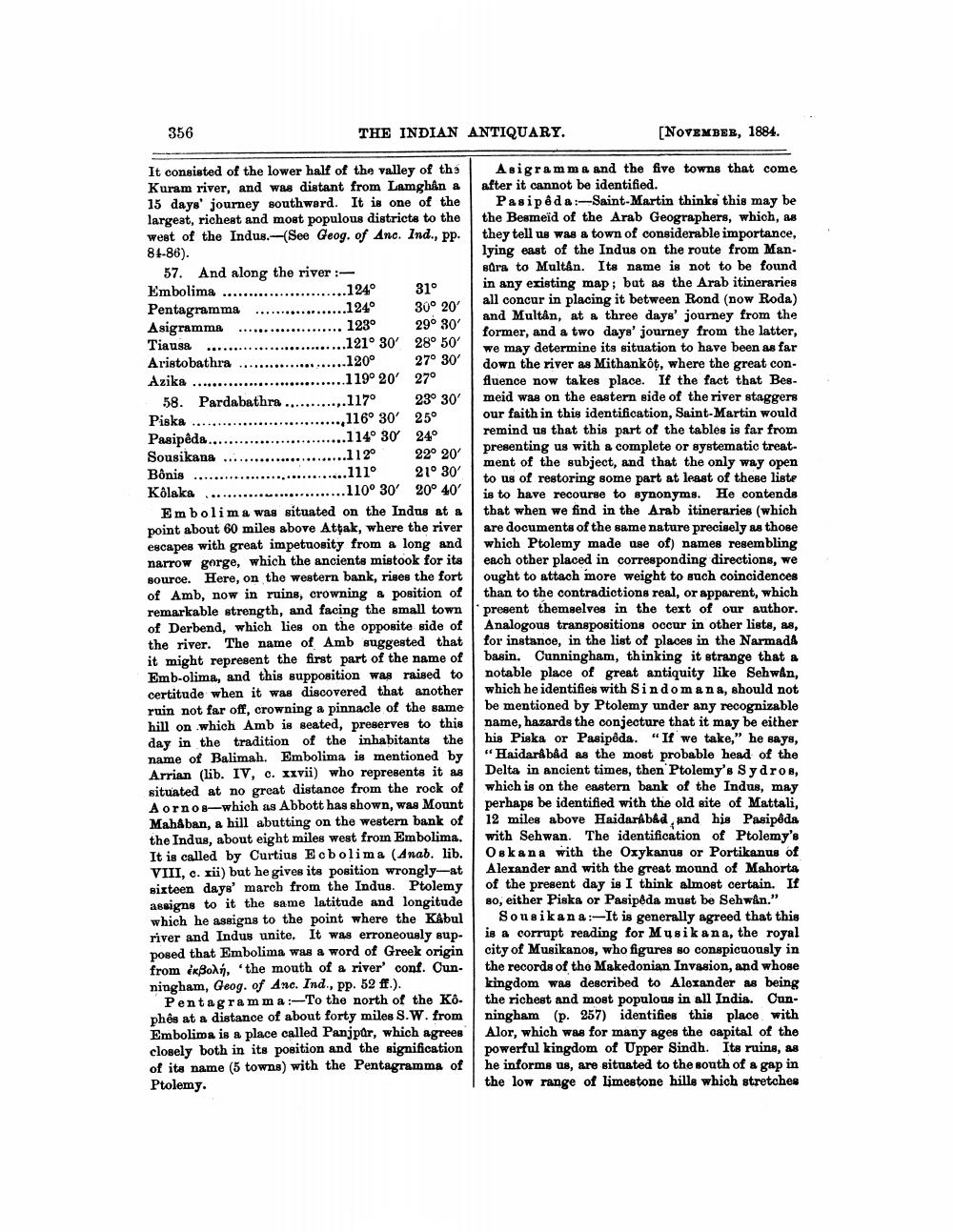
57. And along the river :Embolima ........................124° 31° Pentagramma ..................1 24° 30° 20 Asigramma .................... 123 290 30 Tiausa ........................
..121° 30' 28° 50' Aristobathra .....................120° 27° 30' Azika
..119° 20' 27° 58. Pardabathra ............117° 230 30 Piska ..............................116° 30' 25° Pasipeda...........................114° 30 24° Sousikana .........................112° 22° 20' Bônis ..............................111° 21° 30' Kolaka ...........................110° 30° 20° 40'
Embolima was situated on the Indus at a point about 60 miles above Attak, where the river escapes with great impetuosity from a long and narrow gorge, which the ancients mistook for its source. Here, on the western bank, rises the fort of Amb, now in ruins, crowning a position of remarkable strength, and facing the small town of Derbend, which lies on the opposite side of the river. The name of Amb suggested that it might represent the first part of the name of Emb-olima, and this supposition was raised to certitude when it was discovered that another ruin not far off, crowning a pinnacle of the same hill on which Amb is seated, preserves to this day in the tradition of the inhabitants the name of Balimah. Embolima is mentioned by Arrian (lib. IV, c. xxvii) who represente it as situated at no great distance from the rock of Aornos—which as Abbott has shown, was Mount MahAban, a hill abutting on the western bank of the Indus, about eight miles west from Embolima. It is called by Curtius Ecbolima (Anab. lib. VIII, c. xii) but he gives its position wrongly-at sixteen days' march from the Indus. Ptolemy assigns to it the same latitude and longitude which he assigns to the point where the Kabul river and Indus unite. It was erroneously supposed that Embolima was a word of Greek origin from ikBols. 'the mouth of a river' conf. Cun. ningham, Geog. of Anc. Ind., pp. 52 ff.).
Pentagramma:-To the north of the Ko. phês at a distance of about forty miles S. W. from Embolima is a place called Panjpur, which agrees closely both in its position and the signification of its name (5 towns) with the Pentagramms of Ptolemy.
Asigramme and the five towns that come after it cannot be identified.
Pasipeda:-Saint-Martin thinks this may be the Besmeid of the Arab Geographers, which, as they tell us was a town of considerable importance, lying east of the Indus on the route from Mansura to Multán. Its name is not to be found in any existing map; but as the Arab itineraries all concur in placing it between Rond (now Roda) and Multan, at a three days' journey from the former, and a two days' journey from the latter, we may determine its situation to have been as far down the river as Mithankot, where the great confluence now takes place. If the fact that Bes. meid was on the eastern side of the river staggers our faith in this identification, Saint-Martin would remind us that this part of the tables is far from presenting us with a complete or systematic treat. ment of the subject, and that the only way open to us of restoring some part at least of these liste is to have recourse to synonyms. He contends that when we find in the Arab itineraries (which are documents of the same nature precisely as those which Ptolemy made use of) names resembling each other placed in corresponding directions, we ought to attach more weight to such coincidences than to the contradictions real, or apparent, which present themselves in the text of our author. Analogous transpositions occur in other lists, as, for instance, in the list of places in the Narmada basin. Cunningham, thinking it strange that a notable place of great antiquity like Sehwan, which he identifies with Sindomana, should not be mentioned by Ptolemy under any recognizable name, hazards the conjecture that it may be either his Piska or Pasipôda. "If we take," he says, "Haidarabad as the most probable head of the Delta in ancient times, then Ptolemy's Sydros, which is on the eastern bank of the Indus, may perhaps be identified with the old site of Mattali, 12 miles above Haidarkb&d, and his Pasipeda with Sehwan. The identification of Ptolemy's Oskana with the Oxykanus or Portikanus of Alexander and with the great mound of Mahorta of the present day is I think almost certain. If Bo, either Piska or Pasipeda must be Sehwan."
Souaikana:-It is generally agreed that this is a corrupt reading for Musikana, the royal city of Musikanos, who figures so conspicuously in the records of tho Makedonian Invasion, and whose kingdom was described to Alexander as being the richest and most populous in all India. Cunningham (p. 257) identifies this place with Alor, which was for many ages the capital of the powerful kingdom of Upper Sindh. Its ruins, as he informs us, are situated to the south of a gap in the low range of limestone hills which stretches