________________
DECEMBER, 1884.)
PTOLEMY'S GEOG. BK. VII, CH. 1, $S 93-96.
369
.......
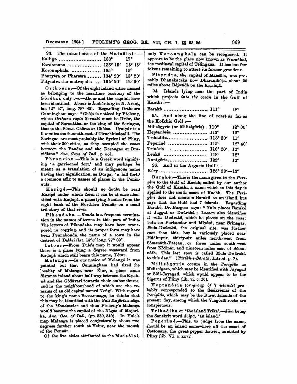
93. The inland cities of the Mais loi:Kalliga........................... 138° 17° Bardamana ..................... 136° 15' 15° 15' Koroangkala .................. 135° 15° Pharytra or Pharetra......... 134° 20' 130 20 Pityndra the metropolis ... 135° 20' 12° 30'
Orthours:-Of the eight inland cities named as belonging to the maritime territory of the Sôrêtai, only two-Abour and the capital, have been identified. Abour is Ambardurg in N. Arkat, lat. 12° 47', long. 78° 42. Regarding Orthoura Cunningham says: “Chôļa is noticed by Ptolemy, whose Orthura regia Sornati must be Uriar, the capital of Soranátha, or the king of the Soringae, that is the Sôras, Chôras or Cholas. Uraiyar is a few miles south-south-east of Tiruchbingpalli. The Soringae are most probably the Syrieni of Pliny, with their 300 cities, as they occupied the coast between the Pandae and the Derangae or Dravidians." Anc. Geog. of Ind., p. 551.
Phrourion: This is a Greek word signify. ing 'a garrisoned fort, and may perhaps be meant as a translation of an indigenous name having that signification, as Durga, '& hill-fort, a common affix to names of places in the Penin. sula.
Karige: This should no doubt be read Karipe under which form it can be at once identified with Kadapa, a place lying 5 miles from the right bank of the Northern Pennar on a small tributary of that river.
Pikendaka :-Konda is a frequent termination in the names of towns in this part of India. The letters of Pikendaka may have been transposed in copying, and its proper form may have been Pennakonda, the name of a town in the district of Baldri (lat. 14°3' long. 77° 39).
Iatour:-From Yule's map it would appear there is a place lying a degree westward from Kadapå which still bears this name, Yêtor.
Malanga :-In our notice of Melange it was pointed out that Cunningham had fixed the locality of Malanga near Elur, a place some distance inland about half way between the Krish. nA and the Godavari towards their embouchures, and in the neighbourhood of which are the remains of an old capital named Vengi. With regard to the king's name Bassaronaga, he thinks that this may be identified with the Pali Majêrika-naga of the Mahdwanso and thus Ptolemy's Malanga would become the capital of the Nagas of Majerika, Ane. "Geo. of Ind., (pp. 589, 540). In Yule's map Malanga is placed conjecturally about two degrees farther south at Velur, near the mouth of the Pennår.
of the five cities attributed to the Maisoloi,
only Koroungkala can be recognized. It appears to be the place now known as Worankal, the mediaval capital of Telingans. It has but few tokens remaining to attest its former grandeur.
Pityndra, the capital of Maisólia, was probably Dhanakataka now Dharaņikota, about 20 miles above Béjwada on the Krishna.
94. Islands lying near the part of India which projects into the ocean in the Gulf of Kanthi :Barakê .............. ...... 111° 18°
95. And along the line of coast as far as the Kolkhic Golf :Milizégyris (or Milizigêris).. 110° 12° 30' Heptandsia
..... 113° 13° Trikadiba .............
..... 113° 30' 11° Pepering ........................ 115° 12040 Trinesis ........................ 116
. 116° 20 12° Lenke ........................... 118 12° Nanigēris................. 1220 12°
96. And in the Argaric Gulf :Kôry .............................. 126° 30'-13°
Barak 8:- This is the name given in the Peri. plas to the Gulf of Kachh, called by our author the Gulf of Kanthi, a name which to this day is applied to the south coast of Kachh. The Peri. plús does not mention Barako as an island, but says that the Gulf had 7 islands. Regarding Barake, Dr. Burgess says: " Yule places Barakê at Jaggat or Dwaraka ; Lassen also identifies it with Dwaraka, which he places on the coast between Purbandar and Miyant, near Srinagar. Mula-Dwaraka, the original site, was further east than this, but is variously placed near Madhupur, thirty-six miles north-west from Sómanáth-Pattan, or three miles south-west from Kôdinar, and nineteen miles east of Somanåth. This last spot is called Mula-Dwaraka to this day." (Tarikh--Sorath, Introd. p. 7).
Milizégyrir occurs in the Periplas as Melizeigara, which may be identified with Jayagad or Sidi-Jayagad, which would appear to be the Sigerus of Pliny (lib. vi, c. 26).
Heptanêsia (or group of 7 islands) probably corresponded to the Sesikrienai of the Periplds, which may be the Burnt Islands of the present day, among which the Vingårld rocks are conspicuous.
Trikadiba or the island Trika', - diba being the Sanskrit word dolpa, an island.
Pepering:- This, to judge from the name, should be an island somewhere off the coast of Cottonara, the great pepper district, as stated by Pliny (lib. VI, c. xxvi).