Book Title: Indian Antiquary Vol 58
Author(s): Richard Carnac Temple, Charles E A W Oldham, S Krishnaswami Aiyangar, Devadatta Ramkrishna Bhandarka
Publisher: Swati Publications
View full book text
________________
THE INDIAN ANTIQUARY
JULY, 1920
meteorological point of view. Up to the Census, cyclones had been recorded in the Bay in every inonth except February, and heavy rain has fallen throughout the year; but cyclones are unusual except from May to November the early part of November being the most likely season for them ; and much rain is not usual from December to May.
Accounts and records show that cyclonic storms struck Port Cornwallis in December 1792, the Archipelago in November 1844, and Port Blair in 1864 and November 1891. There are also abundant signs of a destructive storm between Stewart Sound and Port Cornwallis in 1893. The great storms of 1891 and 1893 travelled across the islands in a north-westerly direction, creating havoc on both East and West Coaste. There is a full and valuable record of the disastrous storm of 1891 (Cyclone Memoirs, No. V., Government of India, 1893).
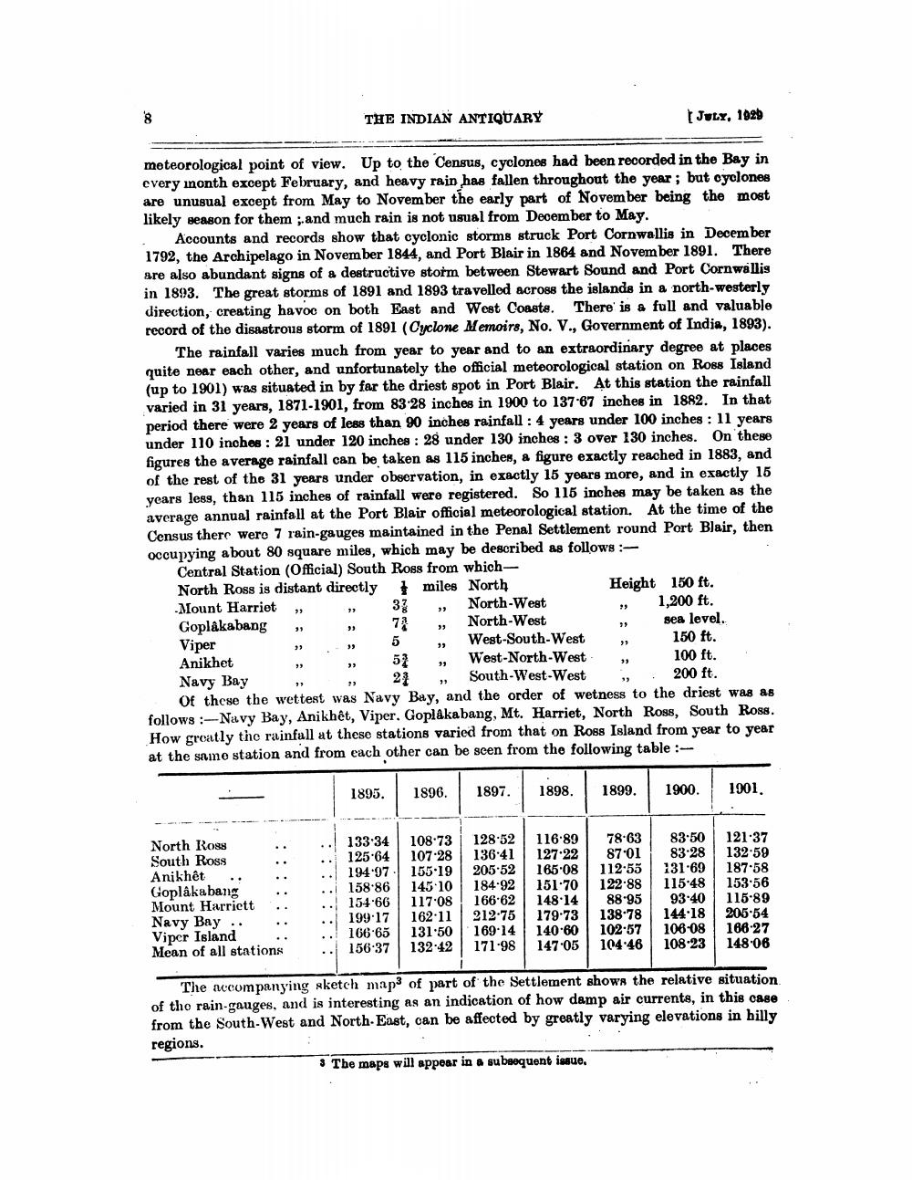
The rainfall varies much from year to year and to an extraordinary degree at places quite near each other, and unfortunately the official meteorological station on Roos Island (up to 1901) was situated in by far the driest spot in Port Blair. At this station the rainfall varied in 31 years, 1871-1901, from 83-28 inches in 1900 to 137.67 inches in 1882. In that period there were 2 years of less than 90 inches rainfall : 4 years under 100 inches : 11 years under 110 inches : 21 under 120 inches : 28 under 130 inches : 3 over 130 inches. On these figures the average rainfall can be taken as 115 inches, a figure exactly reached in 1883, and of the rest of tho 31 years under observation, in exactly 15 years more, and in exactly 15 years less, than 115 inches of rainfall were registered. So 116 inches may be taken as the average annual rainfall at the Port Blair official meteorological station. At the time of the Census there wero 7 rain-gauges maintained in the Penal Settlement round Port Blair, then occupying about 80 square miles, which may be described as follows:
Central Station (Official) South Ross from which North Ross is distant directly miles North
Height 150 ft. Mount Harriet,
37 , North-West Goplâkabang
North-West
» Sea
sea level. Viper
„ West-South-West , 150 ft. Anikhet , , 52 , West-North-West
100 ft. Navy Bay , 21 , South-West-West
200 ft. Of these the wettest was Navy Bay, and the order of wetness to the driest was as follows:- Navy Bay, Anikhet, Viper. Goplakabang, Mt. Harriet, North Ross, South Ross. How greatly the rainfall at these stations varied from that on Ross Island from year to year at the same station and from each other can be seen from the following table :
►
1,200 ft.
*
1895.
1897.1
1898
1899.
1900.
1901
North Ross South Ross Anikhet Goplakabang Mount Harriett Navy Bay .. Viper Island Mean of all stations
133-34 108.73 125.64 107.28 194.97 155.19 158.86 145.10 154.66 | 117.08 199-17 | 162-11 166.65 131.50 156-37 132.42
12852 136 41 205.52 184.92 166.62 212-75 169.14 171.98
116.89 127.22 165.08 151.70 148.14 179.73 140.60 147 05
7863 8701 112.55 122.88
88.95 138 78 10257 104 46
83.50 83.28 131.69 115.48
93 40 144.18 106-08 108.23
121.37 132-59 187.58 153-56 115.89 205-54 166-27 148.06
The nocompanying sketch maps of part of the Settlement shows the relative situation of the rain-gauges, and is interesting as an indication of how damp air currente, in this case from the South-West and North East, can be affected by greatly varying elevations in hilly regions.
3 The maps will appear in a subsequent issue.