________________
December, 1993.
NOTES ON ANTIQUITIES IN RAMANNADESA.
365
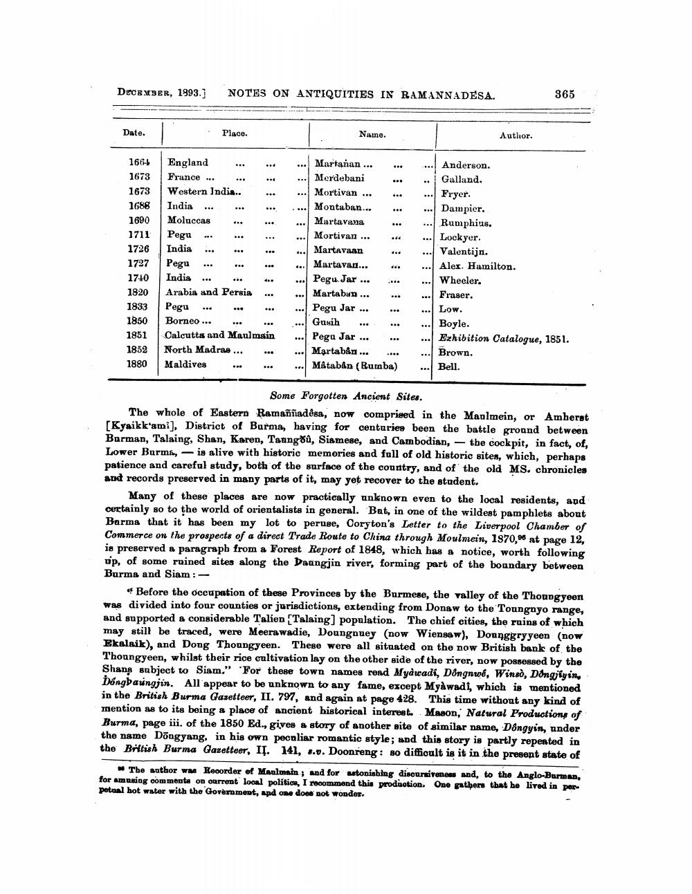
Date.
Place
Name.
Author.
1661673 1673 1688 1690 1711 1726 1727 1740 1820 1833 1850 1851 1852 1880
England France ... Western India.. India ... Moluccas .. Pegu India ... Pegu ... India ... .. .. Arabia and Persia Pegu ... ** Borneo ... ... Calcutta and Maulmain North Madrae ... .. Maldives
Martanan... Merdebani Mortivan ... Montaban... Martavana Mortivan ... Martavaan Martavan... Pegu. Jar... Martaban ... Pegu Jar ... Gusih ... Pegu Jar ... Martabån... .... Måtaban (Rumba)
Anderson. Galland. Fryer. Dampier. Rumphius. Lockyer. Valentijn. Alex. Hamilton. Wheeler. Fraser. Low. Boyle. Exhibition Catalogue, 1851. Brown. Bell.
Some Forgotten Ancient Sites. The whole of Eastern Ramaññadosa, now comprised in the Manlmein, or Amberat [Kyaikk'ami), District of Burma, having for centuriee been the battle ground between Barman, Talaing, Shan, Karen, Taang, Siamese, and Cambodian, - the cockpit, in fact, of, Lower Burma, - is alive with historic memories and full of old historic sites, which, perhaps patience and careful study, both of the surface of the country, and of the old MS. chronicles and records preserved in many parts of it, may yet recover to the student.
Many of these places are now practically unknown even to the local residents, and curtainly so to the world of orientalists in general. Bat, in one of the wildest pamphlets about Barma that it has been my lot to peruse, Coryton's Letter to the Liverpool Chamber of Commerce on the prospects of a direct Trade Route to China through Moulmein, 1870,at page 12, is preserved a paragraph from a Forest Report of 1848, which has a notice, worth following up, of some ruined sites along the Daungjin river, forming part of the boundary between Burma and Siam :
Before the occupation of these Provinces by the Burmese, the valley of the Thoungyeen was divided into four counties or jurisdictions, extending from Donaw to the Toungnyo range, and supported a considerable Talien Talaing] population. The chief cities, the ruins of which may still be traced, were Meerawadie, Doungouey (now Wiengaw), Donnggryyeen (now Ekalaik), and Dong Thoungyeen. These were all situated on the now British bank of the Thoungyeen, whilst their rice cultivation lay on the other side of the river, now possessed by the Shans subject to Siam." "For these town names rend Myawadi, Dongnwo, Wins), Dongiyine Dóngbaungjin. All appear to be unknown to any fame, except Myàwadi, which is mentioned in the British Burma Gazetteer, II. 797, and again at page 428. This time without any kind of mention as to its being a place of ancient historical interest Mason, Natural Productions of Burma, page iii. of the 1850 Ed., gives a story of another site of similar name, Dongyin, under the name Döngyang. in his own pecnliar romantic style; and this story is partly repeated in the British Burma Gazetteer, IĮ. 141, 8.0. Doonreng: so difficult is it in the present state of
The author was Recorder of Maulmin; and for astonishing discursiveness and, to the Anglo-Barman, for Amusing comments on onrrent local polítion, I recommend this production. One gathers that he lived in per petual hot water with the Government, and one does not wonder.