________________
320
THE INDIAN ANTIQUARY.
gives as the distance between successive places lying along the same parallel, that the distance from the Islands of the Blest to the sacred Promontory in Spain (Cape St. Vincent), is 2 degrees, and the distance thence to the mouth of the Betis (Guadalquivir), the same. From the Bætis to Kalpê, and the entrance of the Straits, 2 degrees. From the Straits to Karallis in Sardinia, 25 degrees. From Karallis to Lilybaion, in Sicily, 4 degrees. From this Cape to Pakhynos, 3 degrees. Then again, from Pakhynos to Tainaros, in Lakonia, 10 degrees. Thence to Rhodes, 84 degrees. From Rhodes to Issus, 11 degrees, and finally from Issos to the Euphrates, 2 degrees." § 12. The sum of these particular distances gives a total of 72 degrees, consequently the entire length of the known world between the meridian of the Islands of the Blest and that of the Sêres is 177 degrees, as has been already shown.13 CAP. 13.
§ 1. That such is the length of the inhabited world may also be inferred from his estimate of the distances in a voyage from India to the Gulf of the Sinai and Kattigara, if the sinuosities of the coast and irregularity of the navigation be taken into account, together with the positions as drawn into nearer proximity in the projections; for, he says, that beyond the Cape called Kôry where the
ance in ancient Geography, and many of the meridians were measured from it. The pass has been clearly identified with that now known as the Sirdar Pass between Verâmin and Kishlak in Khowar. Arrian states that the distance from the city of Rhagai to the entrance of the Gates was a one day's march. This was, however, a forced march, as the ruins of Rhagai (now Rai, about 5 miles from Tehran) are somewhere about 30 miles distant from the Pass.
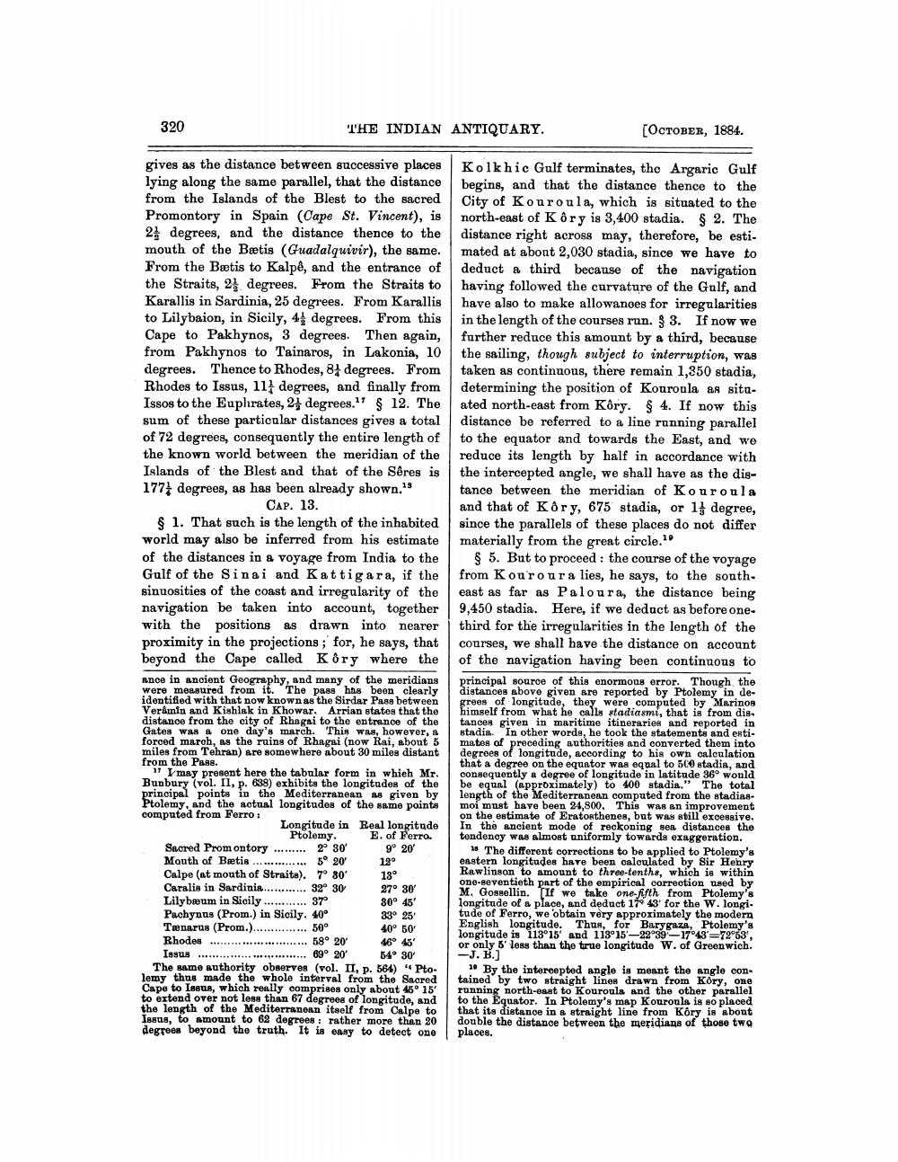
17 I may present here the tabular form in which Mr. Bunbury (vol. II, p. 638) exhibits the longitudes of the principal points in the Mediterranean as given by Ptolemy, and the actual longitudes of the same points computed from Ferro :
Sacred Promontory Mouth of Bætis....... Calpe (at mouth of Straits). Caralis in Sardinia...... Lilybæum in Sicily.
Longitude in Real longitude Ptolemy. E. of Ferro. 2° 30' 9° 20' 5° 20′ 12° 7° 30'
13°
27° 30′
32° 30 37°
30° 45'
Pachynus (Prom.) in Sicily. 40° Tenarus (Prom.)..
33° 25' 40° 50'
50°
Rhodes
58° 20' 69° 20'
46° 45' 54° 30'
Issus.....
The same authority observes (vol. II, p. 564) "Ptolemy thus made the whole interval from the Sacred Cape to Issus, which really comprises only about 45° 15' to extend over not less than 67 degrees of longitude, and the length of the Mediterranean itself from Calpe to Issus, to amount to 62 degrees: rather more than 20 degrees beyond the truth. It is easy to detect one
[OCTOBER, 1884.
Kolkhic Gulf terminates, the Argaric Gulf begins, and that the distance thence to the City of Kouroula, which is situated to the north-east of K ôry is 3,400 stadia. § 2. The distance right across may, therefore, be estimated at about 2,030 stadia, since we have to deduct a third because of the navigation having followed the curvature of the Gulf, and have also to make allowances for irregularities in the length of the courses run. § 3. If now we further reduce this amount by a third, because the sailing, though subject to interruption, was taken as continuous, there remain 1,350 stadia, determining the position of Kouroula as situated north-east from Kôry. § 4. If now this distance be referred to a line running parallel to the equator and towards the East, and we reduce its length by half in accordance with the intercepted angle, we shall have as the distance between the meridian of Kouroula and that of Kôry, 675 stadia, or 1 degree, since the parallels of these places do not differ materially from the great circle.1
§ 5. But to proceed: the course of the voyage from Kouroura lies, he says, to the southeast as far as Paloura, the distance being 9,450 stadia. Here, if we deduct as before onethird for the irregularities in the length of the courses, we shall have the distance on account of the navigation having been continuous to
principal source of this enormous error. Though the distances above given are reported by Ptolemy in degrees of longitude, they were computed by Marinos himself from what he calls stadiasmi, that is from dis tances given in maritime itineraries and reported in stadia. In other words, he took the statements and estimates of preceding authorities and converted them into degrees of longitude, according to his own calculation that a degree on the equator was equal to 500 stadia, and consequently a degree of longitude in latitude 36° would be equal (approximately) to 400 stadia." The total length of the Mediterranean computed from the stadiasmoi must have been 24,800. This was an improvement on the estimate of Eratosthenes, but was still excessive. In the ancient mode of reckoning sea distances the tendency was almost uniformly towards exaggeration.
18 The different corrections to be applied to Ptolemy's eastern longitudes have been calculated by Sir Henry Rawlinson to amount to three-tenths, which is within one-seventieth part of the empirical correction used by M. Gossellin. If we take one-fifth from Ptolemy's longitude of a place, and deduct 17 43' for the W. longi. tude of Ferro, we obtain very approximately the modern English longitude. Thus, for Barygaza, Ptolemy's longitude is 113°15' and 113°15-22°39-17°43-72°53', or only 5' less than the true longitude W. of Greenwich. -J. B.]
10 By the intercepted angle is meant the angle contained by two straight lines drawn from Kory, one running north-east to Kouroula and the other parallel to the Equator. In Ptolemy's map Kouroula is so placed that its distance in a straight line from Kôry is about double the distance between the meridians of those two places.