________________
154
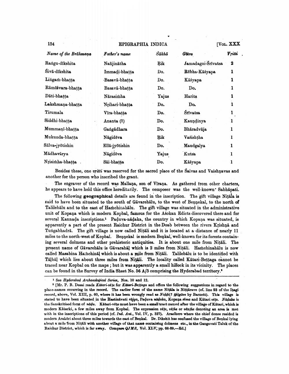
Name of the Brahmaṇa
Rangu-dikshita Sivä-dikshita
Lingah-bhatta
Rāmēsvara-bhaṭṭa
Däti-bhaṭṭa
Lakshmana-bhatta
Tirumala
Siddhi-bhaṭṭa
Mummani-bhatta
Mukunda-bhaṭṭa
EPIGRAPHIA INDICA
Sākhā
Father's name
Nanjinātha
Immadi-bhatta
Basava-bhaṭṭa
Basava-bhaṭṭa
Narasimha
Nrihari-bhaṭṭa
Vira-bhaṭṭa
Ananta (?)
Gangadhara
Nagid va
Elli-jyotishin
Nägidēva
Sai-bhaṭṭa
Rik
Do.
Do.
Do.
Yajus
Do.
Do.
Do.
Do.
Rik
Do.
[VOL. XXX
Vrilli
Jamadagni-Śrīvatsa 2
Rebha-Kasyapa
1
1
1
1
1
Yajus
Do.
Gotra
Kasyapa
Do.
Harita
Do.
Śrīvatsa
1
1
1
1
1
1
1
Koundinys
Phimdvlja
Vasishtha
Maudgalya
Silva-jyotishin
Kutsa
Madhavirya
Nrisimha-bhaṭṭa
Kasyapa
Besides these, one vritti was reserved for the sacred place of the Saivas and Vaishnavas and another for the person who inscribed the grant.
The engraver of the record was Mallana, son of Virana. As gathered from other charters, he appears to have held this office hereditarily. The composer was the well-known Sabhāpati.
The following geographical details are found in the inscription. The gift village Nitāla is raid to have been situated to the south of Gavarehalu, to the west of Bennekal, to the north of Talilebālu and to the east of Hamchinahalu. The gift village was situated in the administrative unit of Kopana which is modern Kopbal, famous for the Asokan Edicts discovered there and for several Kannada inscriptions.1 Paḍuva-naḍaka, the country in which Kopana was situated, is apparently a part of the present Raichur District in the Doab between the rivers Krishņā and Tungabhadra. The gift village is now called Nițali and it is located at a distance of nearly 11 miles to the north-west of Kopbal. Bennekal is modern Beņkal, well-known for its forests containing several dolmens and other prehistoric antiquities. It is about one mile from Nițali. The present name of Gavarehālu is Gavaraha! which is 2 miles from Nițali. Hamchinahālu is now called Masabina Hanchinal which is about a mile from Niṭāli. Talilebālu is to be identified with Tālbal which lies about three miles from Nitali. The locality called Katari-Beṭṭaga cannot be traced near Kopbal on the maps; but it was apparently a small hillock in its vicinity. The places can be found in the Survey of India Sheet No. 56 A/3 comprising the Hyderabad territory.
1 See Hyderabad Archaeological Series, Nos. 10 and 12.
[Mr. P. B. Desai reads Katari-vete for Katari-Bettaga and offers the following suggestions in regard to the place-names occurring in the record. The earlier form of the name Nitala is Nittarave (cf. line 93 of the Itagi record, above, Vol. XIII, p. 60, where it has been wrongly read as Niddi(? #fi)gave by Barnett). This village is stated to have been situated in the Hastinavati rajya, Paduva nadaka, Kopapa sima and Katari vete. Nadaka is the Sanskritised form of nadu. Katari-vete must have been a small tract named after the village of Katari, which is modern Katarki, a few miles away from Kopbal. The expression vete, věthe or venthe denoting an area is met with in the inscriptions of this period (cf. Ind. Ant., Vol. IV, p. 327). Araalkere where the chief donee resided is modern Arakeri about three miles towards the east of Benkal. Dr. Dikshit has confused the village of Benkal lying about a mile from Nițăli with another village of that name containing dolmens etc., in the Gangavati Taluk of the Raichur District, which is far away. Compare QJM8, Vol. XIV, pp. 68.69.-Ed.]