________________
JUNE, 1889.]
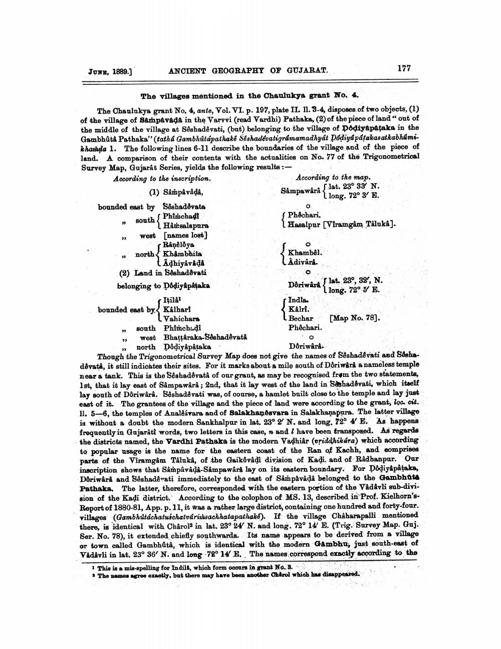
The villages mentioned in the Chaulukya grant No. 4..
The Chaulukya grant No. 4, ante, Vol. VI. p. 197, plate II. 11. 3-4, disposes of two objects, (1) of the village of Sampavada in the Varvvi (read Vardhi) Pathaka, (2) of the piece of land" out of the middle of the village at Sêshadêvati, (but) belonging to the village of Dodiyapataka in the Gambhûta Pathaka" (tatha Gambhútapathaké Séshadévatigramamadhyát Dádiyapáṭakasatkabhúmikhamda 1. The following lines 6-11 describe the boundaries of the village and of the piece of land. A comparison of their contents with the actualities on No. 77 of the Trigonometrical Survey Map, Gujarat Series, yields the following results:
According to the inscription.
(1) Sâmpân vândân,
bounded east by Seshadêvata
Phimchadi
south.
33
ANCIENT GEOGRAPHY OF GUJARAT.
"3
23
west [names lost]
Râpêloya
north Khâmbhila
Adhyāvājā (2) Land in Sêshadêvati
belonging to Dôdiyâpâṭaka
Itilâ1 bounded east by Kalhari Vahichara
South Phimchuḍi
west Bhattaraka-Sêshadêvatâ
north Dôdiyâpâtaka
According to the map. lat. 23° 33′ N. Sâmpawârâ long. 72° 3' E.
O
Phêchari.
{Hasalpur [Viramgam Talukaâ].
Khambêl.
Adivârâ.
Doriwârâ
Indla
Kålri.
Bechar Phichari.
O
Doriwârâ.
7 lat. 23°, 32, N. long. 72° 5' E.
[Map No. 78].
177
Though the Trigonometrical Survey Map does not give the names of Sêshadêvati and Sashadêvatâ, it still indicates their sites. For it marks about a mile south of Doriwârâ a nameless temple near a tank. This is the Sêshadêvatâ of our grant, as may be recognised from the two statements, 1st, that it lay east of Sâmpawârâ; 2nd, that it lay west of the land in Sashadêvati, which itself lay south of Doriwârâ. Sêshadêvati was, of course, a hamlet built close to the temple and lay just east of it. The grantees of the village and the piece of land were according to the grant, loc. cit. 11. 5-6, the temples of Analêávara and of Salakhanesvara in Salakhanapura. The latter village is without a doubt the modern Sankhalpur in lat. 23° 2′ N. and long. 72° 4' E. As happens frequently in Gujarati words, two letters in this case, n and I have been transposed. As regards the districts named, the Vardhi Pathaka is the modern Vadhiâr (vriddhikára) which according to popular usage is the name for the eastern coast of the Ran of Kachh, and comprises parts of the Viramgam Taluka, of the Gaikôvadi division of Kadi. and of Rådhanpur. Our inscription shows that Sâmpâvâdâ-Sâmpawârâ lay on its eastern boundary. For Dôḍiyâpâṭaka, Dôriwârâ and Sêshadêvati immediately to the east of Sâm påvâdâ belonged to the Gambhuta Pathaka. The latter, therefore, corresponded with the eastern portion of the Vâdâvli sub-division of the Kadi district. According to the colophon of MS. 13, described in Prof. Kielhorn'sReport of 1880-81, App. p. 11, it was a rather large district, containing one hundred and forty-four. villages (Gambhútáchatuśchatvárimsachhatapathake). If the village Châharapalli mentioned there, is identical with Chârol2 in lat. 23° 24′ N. and long. 72° 14′ E. (Trig. Survey Map. Guj. Ser. No. 78), it extended chiefly southwards. Its name appears to be derived from a village or town called Gambhûtâ, which is identical with the modern Gambhu, just south-east of Vâdâvli in lat. 23° 36′ N. and long 72° 14′ E. The names correspond exactly according to the
1 This is a mis-spelling for Indila, which form occurs in grant No. 3.
* The names agree exactly, but there may have been another Chirol which has disappeared.