________________
Chapter 06
Climate and Study of Glaciers
Mount Kailas
5200
la
derung Goma 3
andrag Gome
KS-1
4800
Dzong Chu
tha chur
4670 DARCHEN
30 59
Snow Peaks
30 56
Valley floor with ice patches
Marshy Barkha Plain
Barkha Plain
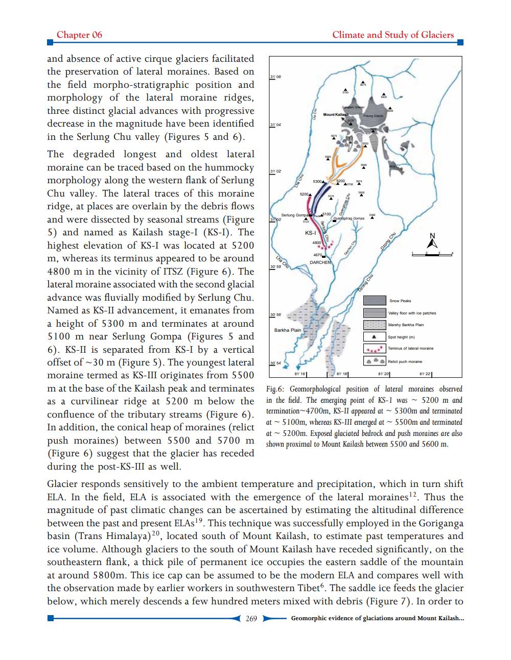
and absence of active cirque glaciers facilitated the preservation of lateral moraines. Based on
ar og the field morpho-stratigraphic position and morphology of the lateral moraine ridges, three distinct glacial advances with progressive decrease in the magnitude have been identified in the Serlung Chu valley (Figures 5 and 6). The degraded longest and oldest lateral moraine can be traced based on the hummocky morphology along the western flank of Serlung Chu valley. The lateral traces of this moraine ridge, at places are overlain by the debris flows and were dissected by seasonal streams (Figure 5) and named as Kailash stage-I (KS-I). The highest elevation of KS-I was located at 5200 m, whereas its terminus appeared to be around 4800 m in the vicinity of ITSZ (Figure 6). The lateral moraine associated with the second glacial advance was fluvially modified by Serlung Chu. Named as KS-II advancement, it emanates from a height of 5300 m and terminates at around 5100 m near Serlung Gompa (Figures 5 and 6). KS-II is separated from KS-I by a vertical offset of -30 m (Figure 5). The youngest lateral
Relict puch moralne moraine termed as KS-III originates from 5500
87 16 8 18
87 201 8 T22 m at the base of the Kailash peak and terminates Fig.6: Geomorphological position of lateral moraines observed as a curvilinear ridge at 5200 m below the in the field. The emerging point of KS-1 was - 5200 m and confluence of the tributary streams (Figure 6).
termination-4700m, KS-II appeared at - 5300m and terminated
at - 5100m, whereas KS-III emerged at 5500m and terminated In addition, the conical heap of moraines (relict
at - 5200m. Exposed glaciated bedrock and push moraines are also push moraines) between 5500 and 5700 m shown proximal to Mount Kailash between 5500 and 5600 m. (Figure 6) suggest that the glacier has receded during the post-KS-III as well. Glacier responds sensitively to the ambient temperature and precipitation, which in turn shift ELA. In the field, ELA is associated with the emergence of the lateral moraines 2. Thus the magnitude of past climatic changes can be ascertained by estimating the altitudinal difference between the past and present ELAS19. This technique was successfully employed in the Goriganga basin (Trans Himalaya)20, located south of Mount Kailash, to estimate past temperatures and ice volume. Although glaciers to the south of Mount Kailash have receded significantly, on the southeastern flank, a thick pile of permanent ice occupies the eastern saddle of the mountain at around 5800m. This ice cap can be assumed to be the modern ELA and compares well with the observation made by earlier workers in southwestern Tibet6. The saddle ice feeds the glacier below, which merely descends a few hundred meters mixed with debris (Figure 7). In order to
269 Geomorphic evidence of glaciations around Mount Kailash...
Spot height (m)
Teminus of lateral moraine